These files are in a format that requires an Adobe Acrobat Reader for viewing. Most
computers already have this tool. If your computer does NOT have the reader, it is
available as a FREE download from the Adobe Website. Use this link to go to the Adobe
website download page: 
| Index Map of Series L7014 Topographic Mapsheets |
Valuable map showing the
locations of all of the South Vietnam Topographical Mapsheets, 1:50,000 scale, Series
L7014, with UTM Codes (2-letter prefixes) overlay in red. Download File Size: 2688 kb. |
| LZ Geronimo - Tam Quan Vicinity |
LZ Geronimo: BS878-170, LZ Lowboy: BS913-147. Tam
Quan: BS900-130. Map created at the request of Jeff Felder (Charlie Company, 12-67
to 12-68) Download File Size: 274 kb. |
| Tam Quan - Bong Son Area |
LZ English: BS879-005, LZ English North:
BS883-056, LZ Tom: BS900-090, LZ Lowboy: BS913-147(Slightly Northeast of Tam Quan and not
on this map). This important area of our operations in 1967 and 1968 was the scene of the
Battle of Tam Quan, from 6 to 20 December, 1967. Download
File Size: 461 kb. |
| The "Crow's Foot" Area |
Series of valleys 20 kilometers West of LZ
Uplift. Nicknamed for it's distinctive shape. Created from portions of Map Series TL 7014,
Sheets 6737-I and 6737-II. Also included is a page on the ancient symbolism of the
"Crow's Foot". Download File Size: 983 kb. |
| The
Cay Giep Vicinity |
"Tiger Mountain", "Old
Baldy", LZ Quick, Hill 641....Cay Giep (BR 931-903) was the most prominent landmark
of the LZ Uplift Area of Operations. Created from Map Series TL 7014, Sheet 6837-IV...also
includes some great photos! Download File Size: 827 kb. |
| An Bao - Dam Tra O Vicinity |
This map includes the Villages at An Bao, scene
of the Battle of An Bao, from 5 to 6 May, 1968.(BR906795)
Download File Size: 1,268 kb. |
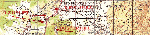
| LZ
Uplift Vicinity |
Map of area including LZ Uplift, LZ Ichiban, 8
Inch Hill, Duster Hill, and LZ Litts. Download File Size:
1,270 kb |
| Nui Mieu Mountains and Route 505 |
Map of area including LZ Uplift, East and South
of same. Taken from portions of Map Series L7014, Sheets 6837-III (Phu My) and 6837-IV
(Bong Son). Download File Size: 793 kb. |
| 506 Valley |
Map of 506 Valley, West of LZ Uplift, with photos
by Bill Moore and Dick Guthrie. Download File Size:458 kb |
| Suoi
Ca Valley |
Map of The Suoi Ca Valley (BR800-660), SSW of LZ
Uplift, with notations taken from Battalion History for July to September of 1968. Map
inspired by Rigo Ordaz's description of the Scout Platoon.
Download File Size: 287 kb |
| Qui
Nhon Port |
Map and pictures of the Qui Nhon City and Port
Area. Download File Size: 413 kb |
| An Khe Pass |
Map of section of Higway 19, showing the An Khe
Pass. Both portion of Map Series L7014 6736-I (as well as two Aerial Photos). Download File Size: 297 kb. |
| Camp Radcliff Vicinity |
This map covers the area between the
Mang Yang and Anh Khe Pass and shows all key locations. Download File Size(LARGE): 4.8 Mb. |
| Mang Yang Pass & Pump Station 8
|
Map of section of Higway 19, centered on Pump
Station 8 and also showing the infamous Mang Yang Pass as well as LZ Action. Also included
are a Photo of the edge of the Mang Yang Pass and the Daily Staff Journal specific to the
SRAP action of 21 March 1969. Download File Size: 1612 kb. |
| Phan Thiet Vicinity |
Map of area including LZ Betty and Phan Thiet.
Photo used with permission of http://www.lzbetty.com/.
Download File Size: 751 kb |
| Thien Giao Vicinity |
Map of Thien Giao area, North of Phan Thiet.
Includes photo taken from a Huey provided by Ray Sarlin. Download
File Size: 379 kb |
| Whiskey Mountain |
Prominent Landmark North and West of Phan Thiet. Download File Size: 166 kb |
| Le Hong Phong Forest Vicinity |
Map of the Le Hong Phong Forest located North of
Phan Thiet, East of Highway 1, and South of the Song Cai River and Song Mao in Binh Thuan
Province. Photo used with permission of http://www.lzbetty.com/
Also a James Dacus Photo. Much thanks to Bob Camors for correcting me on the previously
posted map which was off by over 30 clicks! Good thing I wasn't a Scout! Download File Size: 1,056 kb |
| Song
Mao Vicinity |
Map of the Song Mao area, Northeast of Phan
Thiet. Download File Size: 358 kb |
| Vinh
Hao Vicinity (Firebase Panzer) |
Area along the coast, Northeast of Phan Thiet,
Including location of LZ Panzer: BN523483. Map created at the suggestion of Rick Rajner,
"A" Company, coordinates confirmed by "Skip" Fee, Former Platoon
Leader from "C" Troop, 2/1st Cav. Includes three photos of the Fire Base
contributed by Harvey Hummel, "B" Company, 1969-70, with thanks to Bryan
"Frenchy" Lagimoniere for acquiring and submitting the photos for Harvey. Download File Size: 542 kb |